

During the 1980s, I got to fly almost all over the USA; it was a (welcome) job requirement. When traveling from one coast to the other, I usually transited through O’Hare airport in Chicago.
I remember the first time I experienced the “tunnel of lights” between the B and C concourses. Instead of dragging my suitcase on a numbing people mover confined within drab concrete walls, I found myself transported through a luminous wonderland: bright waves of multicolor neon tubes undulating from the ceiling while complimentary glass blocks lit up the walls. A rainbow of colors cycled rhythmically to the tune of Rhapsody in Blue. What a beautiful way to conjugate art and practicality.
Thirty years later, I always look forward to landing at a C gate. Michael Hayden’s The Sky’s The Limit art installation is familiar, yet still exciting. I feel like a little kid enjoying a two-minute ride in Disneyland: a spring in my step, a smile on my face, and peace on my mind.

SHOOTING THE SHOOTER
Sometimes the photographer becomes the subject. Palais Royal in the first arrondissement ranks as one of the most popular locations for photo shoots: the juxtaposition of classic architecture and modern elements (the often decried Buren columns) provides interesting props.
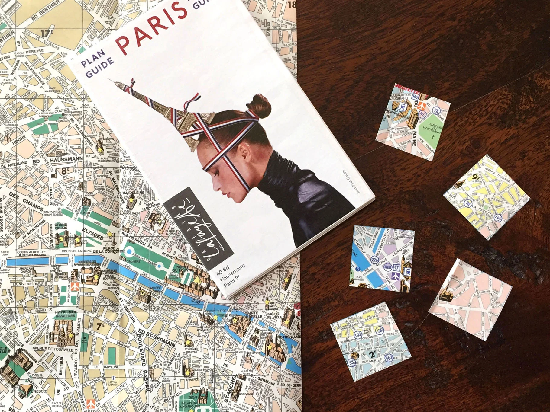
MAPS-THE GAME
When you’re a frequent Paris visitor, it’s easy to get sucked into your comfort zone: you stay at the same hotel or apartment; you have your favorite neighborhood and know exactly which pastry shop has the most succulent tarte au citron; you’re on a first-name basis with the chef who runs that great bistro you love so much.
I understand the attraction: you don’t want to be a mere tourist; you want to belong. I’ve been guilty of doing that myself. So, let me tell you about this little game I’ve been playing for a few years. I picked up two of the free maps that you routinely find at the airport or in hotel lobbies (they usually advertise the Galeries Lafayette department store.) I unfolded one of them, cut the city map along the grid, and obtained about 120 squares. I did allow myself to discard those on the outer edge where the only place of interest was the boulevard périphérique… Each one measures about 1.25” x 1.25” and I keep them all in a box. Before each visit, I pick one. Randomly. Then I make sure to devote at least half a day to explore my “assigned” area, trying to walk every little street, paying attention to architectural details, looking for surprising places, and taking photos of what I encounter.
I keep the second map as a reference so I can easily spot where my square fits overall: some of the mostly residential areas can be hard to locate when they don’t include part of the river or a recognizable monument. Once I know where I’ll be walking, I make a copy of a real street map of the area and take it along: I can always see the “boundaries” of my square and don’t need to rely on a phone app. I strongly recommend Paris 3 Plans par Arrondissement (which is a bit hard to find these days) but I’ve also used the Michelin Paris Plan (royal blue #11.)
You can also decide to explore beyond the strict limits of your square: it usually makes sense to cover the length of a street or walk around a whole park. Whether you consult guides, prepare your itinerary, or just go blindly is entirely up to you. Either way, I’m sure you’ll make unexpected discoveries. Give it a try!
Vocabulary
Tarte au citron: lemon tart
Boulevard péripherique: the beltway circling around the city